On a hot day, rural environments will feel cooler than urban environments. In rural areas, water is taken up by plant roots; it then moves to the leaves and evaporates from leaf pores in a process called transpiration. This process cools leaf surfaces, which in turn cool nearby air. Evaporation also occurs from moist soil surfaces, cooling the air close to the surface. We refer to the combined effects of transpiration and evaporation as evapotranspiration.
There are other reasons why urban surfaces are hotter than rural ones. Many city surfaces are dark, and strongly absorb solar energy. In fact, asphalt paving absorbs more than twice as much solar energy as vegetation. Rain runs off the roofs, sidewalks, and streets into storm sewer systems. Because the city surfaces are dry, there is little evaporation to help lower
temperatures.

Another important factor is waste heat. In summer, city air temperatures are raised by air conditioning, which pumps thermal energy out of buildings and releases it to the air. In winter, thermal energy from buildings and structures is conducted directly to the urban environment.
THE URBAN HEAT ISLAND
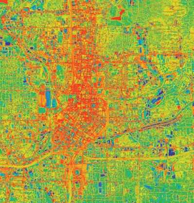
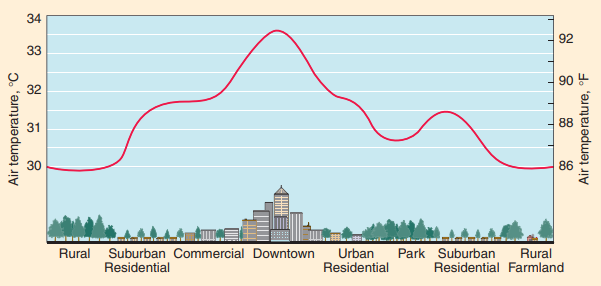
As a result of these effects, air temperatures in the central region of a city are typically several degrees warmer than those of the surrounding suburbs and countryside. The sketch of a temperature profile across an urban area in the late afternoon shows this effect. We call the central area an urban heat island, because it has a significantly elevated temperature. At night, the thermal energy conducted into the ground and urban structures flows outward, warming the night air so that the heat island remains warmer than its surroundings during the night, too. The thermal in image of the Atlanta central business district at night demonstrates the heat island effect.
The urban heat island effect has important economic consequences. Higher temperatures in the summer raise the demand for air conditioning and electric power. The fossil fuel burned to generate this power contributes CO 2 and air pollutants to the air. The increased temperatures can escalate smog formation, which is unhealthy and damaging to materials. To reduce these effects, many cities are planting more vegetation and using more reflective surfaces, such as concrete or bright roofing materials, to reflect solar energy back to space.
The heat island effect does not necessarily apply to cities in desert climates. In the desert, the evapotranspiration of the irrigated vegetation of the city may actually keep the city cooler than the surrounding barren region.
HIGH-MOUNTAIN ENVIRONMENTS
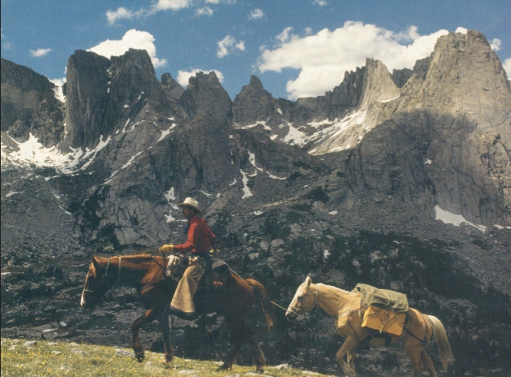
We have seen that the ground surface affects the temperature of the air directly above it. But what happens as you travel to higher elevations? For example, as you climb higher on a mountain, you may become short of breath, and you might notice that you sunburn more easily. You also feel the temperature drop, as you ascend. If you camp out, you’ll see that the nighttime temperature drops lower than you might expect, even given that temperatures are generally cooler the farther up you go.
What causes these effects? At high elevations there is significantly less air above you, so air pressure is low. This makes it more difficult to catch your breath, simply because of the reduced oxygen pressure in your lungs. And with fewer molecules to scatter and absorb the Sun’s light, the Sun’s rays will feel stronger.
There is less carbon dioxide and water vapor, and so the greenhouse effect is reduced. With less warming, temperatures will tend to drop even lower at night. Later in this chapter, we
will see how this pattern of decreasing air temperature extends high up into the atmosphere.
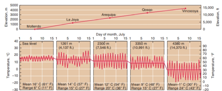
Temperature graphs for five stations at different heights in the Andes mountain range in Peru. Mean temperatures clearly decrease with elevation, from 16°C (61°F) at sea level to 2 1 ° C(30°F) at 4380 m (14,370 ft). The range between maximum and minimum temperatures also increases with elevation, except for Qosqo. Temperatures in this large city do not dip as low as you might expect because of its urban heat island.
Useful External Links
- Urban Areas and Urban–Rural Contrasts under Climate Change: What Does the EURO-CORDEX Ensemble Tell Us?—Investigating near Surface Humidity in Berlin and Its Surroundings by Gaby S. Langendijk, Diana Rechid, Daniela Jacob
- Determinants of urban–rural land surface temperature differences – A landscape scale perspective by Michael Heinl, Albin Hammerle, Ulrike Tappeiner, Georg Leitinger
- The relationships between urban-rural temperature difference and vegetation in eight cities of the Great Plains by Yaoping Cui, Xiangming Xiao, Jinwei Dong