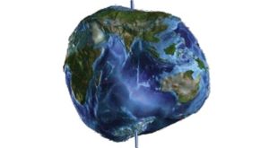
The Shape of the Earth
As we all learn early in school, the Earth’s shape is very close to a sphere. Pictures taken from space by astronauts and by orbiting satellites also show us that the Earth is a ball rotating in space.


Today it seems almost nonsensical that many of our ancestors thought the world was flat. But to ancient sail-ors voyaging across the Mediterranean Sea, the shape and breadth of the Earth’s oceans and lands were hid-den. Imagine standing on one of their ships, looking out at the vast ocean, with no land in sight. The surface of the sea would seem perfectly flat, stretching out and meeting the sky along a circular horizon. Given this view, perhaps it is not so surprising that early sailors, believing the Earth was a flat disk, feared their ships would fall off its edge if they ventured too far from land.
We also gain information about the shape of the Earth when we watch the Sun set when there are clouds in the sky. The clouds continue to receive the direct light of the Sun, although it has already set, as seen at ground level. The movement of solar illumination across the clouds is easily explained by a rotating spherical Earth.
Actually, the Earth is not perfectly spherical. The Earth’s equatorial diameter, at about 12,756 km (7926mi), is very slightly larger than the polar diameter, which is about 12,714 km (7900 mi). As the Earth spins, the outward force of rotation causes it to bulge slightly at the equator and flatten at the poles. The difference is very small—about three-tenths of 1 percent—but strictly speaking the Earth ’s squashed shape is closer to what is known as an oblate ellipsoid, not a sphere.
An even more accurate representation of the Earth’s shape is the geoid, which is a reference surface based on the pull of gravity over the globe. It is defined by a set of mathematical equations and has many applications in mapmaking, as well as navigation.


The Earth’s Rotation
The Earth spins slowly on its axis—an imaginary straightline through its center and poles—a motion we refer to as rotation. We define a solar day by one complete rotation, and for centuries have chosen to divide the solar day into exactly 24 hours. The North and South Poles are defined as the two points on the Earth’s surface where the axis of rotation emerges.

The Earth ’s rotation is important for three reasons. First, the axis of rotation serves as a reference in setting up the geographic grid of latitude and longitude, which we will discuss later in the chapter. Second, it provides the day as a convenient measure of the passage of time,with the day in turn divided into hours, minutes, and seconds. Third, it has important effects on the physical and life processes on Earth.
ENVIRONMENTAL EFFECTS OF THE EARTH’S ROTATION
All forms of life on the planet’s surface are governed by the daily rhythms of the Sun. Green plants receive and store solar energy during the day and consume some of it at night. Among animals, some are active during the day, others at night. The day–night cycle also sets in motion the daily air temperature cycle that is observed in most places on the Earth.
The directions of large motions of the atmosphere and oceans are also affected, as the turning of the planet makes their paths curve. As we will see in Chapter 5, weather systems and ocean currents respond to this phenomenon, which is known as the Coriolis effect .
Finally, the Earth’s rotation, combined with the Moon’s gravitational pull on the planet, causes the rhythmic rise and fall of the ocean surface, which we know as the tides. The ebb and flow of tidal currents is a life-giving pulse for many plants and animals and provides a clock that regulates many daily human activities in the coastal zone. When we examine the tide and its currents in greater detail in Chapter 16, we will see that the Sun also has an influence on the tides.


